By Sourav Roy
New Delhi: The Special Representatives of India and China completed their 11th round of talks on the border September 26 without much to show for it.
The border has plagued bilateral relations ever since Independence, with China refusing to accept the McMahon Line drawn by the British as an eImperial legacy. The two nations even fought a brief war over it in 1962.
But India’s position that the McMahon line should be the border may come back to haunt it if Chinese actually agree. Because large tracts of land in Arunachal Pradesh which are patrolled by Indian troops today are officially shown as Chinese territory in maps officially certified by the Survey of India.
What is even more appalling, almost two decades after this major error was pointed out to the government by a decorated war hero, nothing has been done.
After intense debates over whether we should run this article, we finally decided to do so for one simple reason: The truth must be told.
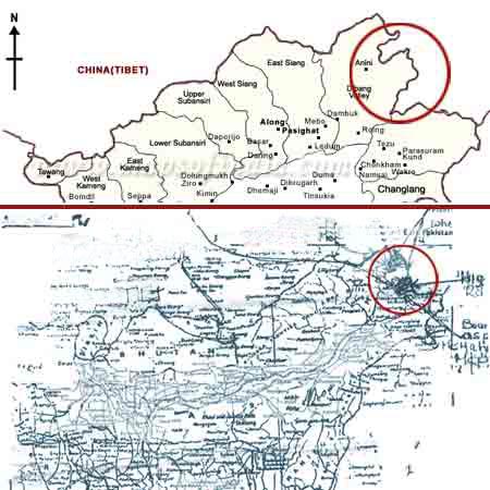
A Himalayan Blunder by Indian cartographers has led to a piquant situation along the disputed India-China border, with Indian troops patrolling a region which the official Survey of India maps show as Chinese territory.
Way back in December 1988, this glaring mistake was brought to the notice of the then Minister of External Affairs, P.V.Narasimha Rao, by the 1971 Bangladesh war hero and the former Chief of Staff and Army Commander, Eastern Command, Lt General J F R Jacob.
In his reply to General Jacob dated December 24, 1988, Rao, who later became the Prime Minister of India, accepted "the contradictions that India faced" and admitted that publishing maps with a border that the Chinese might use to their advantage could indeed be a grave issue. "We hope to resolve these in a proper way when we can discuss constructively with the Chinese," he wrote.
However, "the changing of maps at a time when substantive discussions with the Chinese take place also needs to be considered," wrote Rao. Twenty years later, the incorrect maps remain unchanged.
India and China have been locked in a bitter border dispute since India’s Independence, which even led to a border war in 1962. Though the two sides agreed in the early 80s to put the issue on the backburner while focusing on other interests, attempts to find common ground on the border have yielded little.
Source: Sify.com