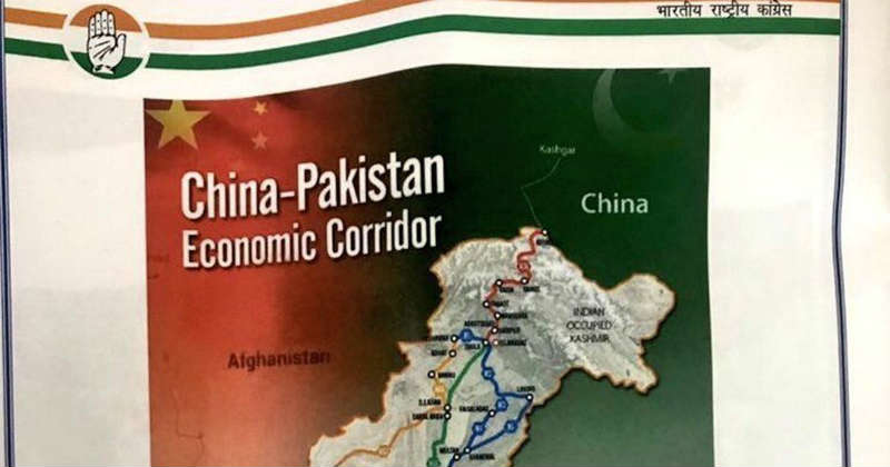
Lucknow : The Congress party on Saturday committed a blooper when its senior leader Ghulam Nabi Azad released a booklet with a map of Jammu and Kashmir shown as Indian occupied Kashmir, drawing stinging criticism from the ruling BJP.
Azad, the Congress’ leader in the Rajya Sabha, was in Lucknow where he attacked the Modi government for its “failures”, including those in handling India’s relations with Pakistan and China.
At the press conference, he released a booklet which contained a map showing Kashmir as Indian occupied Kashmir.
The BJP quickly latched on to the faux pas to attack its arch rival, saying it must have gladdened the heart of its “patrons in Pakistan”.
On its part, the Congress party apologised for the “big mistake”, admitting that it was its responsibility to ensure that such a map was not released. It, however, claimed the BJP had released a similar map on its website but never admitted to the mistake.
“It is not only regrettable but shocking that a senior Congress leader like Azad is projecting a map of Kashmir where it is described as Indian occupied Kashmir. Is Congress speaking the language of Pakistan?
“A Parliament resolution says even Pakistan occupied Kashmir is part of India. By projecting Kashmir as Indian occupied Kashmir the Congress party has not only made separatists happy but also gladdened the heart of its patrons across the border. It is condemnable,” union inister Ravi Shankar Prasad said.
Shrikant Sharma, a minister in the Uttar Pradesh government and its spokesperson, alleged that releasing such a map amounted to “treason” and Congress chief Sonia Gandhi should apologise for it.
He said it was not the first time that the Congress was speaking Pakistan’s language, alleging its vice president Rahul Gandhi had gone to JNU to sympathise with “traitors” and the party had also questioned the authenticity of cross-LoC surgical strikes to “bring down” the Army’s morale.
Congress leader Ajay Maken said it was a “printing error” but admitted that it was his party’s responsibility to ensure that such a mistake was not allowed.
“We apologise for this and will ensure that such a mistake is not repeated,” he said.
Targeting the BJP, he said its website had on 28 March, 2014 shown a similar map. He claimed a map which was released the same year in September during the signing of a treaty with China in the presence of Prime Minister Narendra Modi had shown Arunachal Pradesh as part of China.
The difference between the BJP and the Congress is that “we admit our mistake but they don’t”.
“Before raising questions, they should respond to publication of such maps,” he said.
Source : Firstpost