A day after social media behemoth Twitter showed Jammu and Kashmir, Ladakh as separate countries, search engine giant Google showed a distorted map of India, depicting Pakistan Occupied Kashmir and Aksai Chin as separate entities and not a part of the Indian Union.
In addition to this, Google has also marked the union territories of Jammu and Kashmir, Ladakh and the state of Arunachal Pradesh as disputed regions. The distorted map of India appears in a section on the Google Trends website.
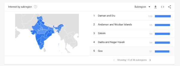
As can be seen from the above screenshot, the regions of Pakistan Occupied Kashmir and Aksai Chin are displayed in grey with crossed lines while the rest of the country is depicted in different shades of blue. Furthermore, while Jammu and Kashmir, Ladakh and Arunachal Pradesh are represented in blue colour, they are distinctly marked with cross lines, suggesting that the regions are under dispute.
The discrepancy in the Indian map on Google was highlighted by a Twitter user, who accused the search engine giant of brazenly pandering to Beijing, which has banned its services in China. The user said that despite the fact that the Indian government has released the maps of Union Territories of Jammu and Kashmir, Ladakh and the overall Indian map, Google has not been using them to depict the country.
And kindly remove those outlines from Arunachal Pradesh conveying it as a disputed region.
And why always after pleasing nations like China ??? Does Chinese govt even a give a shit about your applications?
Kindly stop taking your huge user-base of India ?? for granted ?.— Sunny Nehra (@sunnynehrabro) June 29, 2021
This is not the first time that Google has been subjected to criticism for publishing a distorted version of the map of India. In February 2020, Google’s population navigation services, Google maps had redrawn Kashmir’s borders that appeared different when searched from outside India. It showed Kashmir’s outlines as a dotted line acknowledging “dispute” when it is viewed from outside India.
According to a report by the Washington Post, the borders on Google’s online maps displayed Kashmir as an integral part of India when viewed from India, contrary to what it appeared when seen from elsewhere. For example, when viewed from Pakistan, the Kashmir region would appear disputed marked with dotted lines.
In 2013 too, Google Maps had come under criticism for showing PoK and Aksai Chin (and parts of Arunachal Pradesh) outside the Indian map, and the then government had asked it to correct it.
Source : OpIndia